|
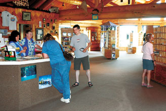
Talk About Tok Travelers coming from the “Lower 48” know they’ve finally arrived when they hit Tok. It’s the first roadside town in Alaska, and has a visitor center. Tok has a collection of businesses, where you can wash off, dry out, stock up, eat up and bed down, no matter whether you’re headed into or out of Alaska. Tok has a festive, port-city air (though it's nowhere near the ocean). Alaska time is an hour earlier than the Yukon, so set your watch. |
The Alaska Highway border crossing is typically 24 hours a day year-round. The Top-of-the-World border crossing
is typically open 12 hours a day from mid-May to mid-September. |
If you're entering Alaska by way of Canada, stop at the Tetlin National Wildlife Refuge Visitor Center, 9 miles from the Canada border. For the next 70 miles on your way toward Tok, the southern side of the Alcan Highway borders the refuge. Eastern Alaska is one of the most animal-dense areas of the state. For example, it's estimated by biologists that the 40-Mile Caribou Herd, north of Tok, numbered 33,110 animals in the year 1999, and the 40-Mile Herd is growing. South of the 40-Mile area, in the Copper River Valley, the Nelchina Caribou Herd is now estimated at around 30,000 animals. In the mid-1990's, the Nelchina Herd numbered over 50,000 caribou. (Local biologists say that was too many. The larger number of caribou over used the Nelchina summer range.) The Nelchina herd roams a vast area in Alaska, and has been overwintering near Tok and the Canada border in recent years. The 730,000 acre Tetlin Wildlife Refuge produces up to 100,000 ducklings a year. Home to 186 or more bird species. Interior Alaska lakes are important summer habitat for many birds.. + For general tips on spotting wildlife in Alaska, click here. |
Northway Junction On your way into Tok from Canada, you'll pass Northway Junction. Northway Village is 7 miles off the road, and is named after Chief Walter Northway, who lived to be 117, and died in 1993. (Its Athabascan name is "Naabia Niign," which means, "Our Village Along the River.") Chief Northway saw his first gold miners while a child, and is said to have helped save their lives. (Contrary to popular belief, many of the gold rush stampeders of a hundred years ago were not particularly good woodsmen.) Northway and nearby Tetlin are Athabascan Indian villages. The town of Northway itself has some of the coldest winter temperatures in Alaska. There are many advantages to living so far north, however. For instance, as the photo shows, living close to the Tetlin National Wildlife Refuge gives young people from Tetlin Village a chance to participate in banding osprey with state and federal agencies. Northway has a post office, a school, an airport, and a population of about 350 people. Two miles south of the village, there's an airport with a U.S. Customs Office. |
Tetlin Junction and the Taylor Highway
The original road to Eagle, called "The Eagle Trail," was built in the early 1900's, and ran from Fort Egbert at Eagle to Valdez. The route was used by early miners as an American route to the Klondike, and later, to the 40-Mile Gold Mining District. Remnants of the original trail still exist, and can be seen between here and Valdez. It wasn't easy finding a good road route through Interior Alaska in the summer because the permafrost (permanently frozen ground) prevents water from draining, creating in the process large swampy bogs. The most successful trails through Interior Alaska were those originally developed by Native Americans. Around 6 miles out of Tok, there's the Coast Guard's LORAN-C station. Its signal towers provide navigational information for air and sea travel in the Gulf of Alaska. |
|
|||
|
|||
|
|||
|


 Tok is 92 miles
from the Canada border. Its name rhymes with “smoke.”
 The
Alcan Highway, along which you'll be traveling when you drive into Tok,
was a military road built in anticipation of World War II. It was
constructed at a cost of $138 million and finished in late October,
1943, as a way of giving the military road access to Alaska.
